


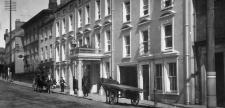
The old Royal Hotel in Enniskillen
BOTH visitors and locals will be able to enjoy the sites and history of Enniskillen like never before – following the launch of a new historical walking tour app.
The app, which has been in development for the last six months by Fermanagh District Council and McCadden Ltd, a Belfast design company, is now available for use.
Covering 30 sites – the app gives users an opportunity to tour the town on foot, view old images and read up on the history of each ‘stop’.
The guided walk is accessible through an innovative web based app which you can access from your smart device.
Simply go to www.ekn.guide and you can follow the route as you wish and follow in the footsteps and echoes that have gone before.
There are 30 stops along the way; each one with a story to tell whether it is a church, a pub or a convent.
Among the historical sites featured in the app are:
Queen Street:
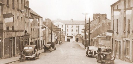
Queen Street
Queen Street was formerly known as Barracks Lane (later Street) and Brewery Lane (Downes Brewery was located where Portora Wharf now stands). Queen Street was the principal street on the west of the town; it was at one time a thriving area – both commercially and socially. Located at the bottom of Queen Street was the Militia Barracks, more recently the ‘Militia Hall’. At the junction of Queen Street and Head Street stands what was known as ‘The She Barracks’ – the married quarters or more recently, Proctor’s Flats. Sharp’s Row was named after John Sharp who in 1803 built houses at junction between Head Street and Queen Street.
The Royal Hotel:
The old Royal Hotel in Enniskillen
The Royal Hotel was opened by a Mr Edward Monaghan. Monaghan first had premises at Nugent’s House (Nugent’s Entry), but during the 1860s he moved to the site closer to the East Bridge. The Royal Hotel/present bank building is an amalgamation of three houses. The present bank building retains the impressive hotel porch way.
West Bridge:
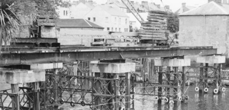
West Bridge
The first wooden West Bridge was built by the Planters and had a draw-bridge. The first stone bridge had at least eight arches. This was replaced in 1773 by a 3 arch stone structure with parapets of iron railings. It, in turn, was later replaced by a third bridge, constructed between 1885 and 1892.
Peg O’ The Bull lane:
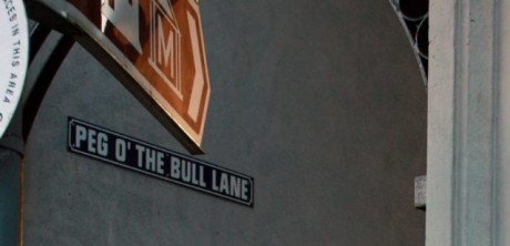
Peg O’ the Bull lane
The correct name of this little alleyway that runs alongside St Michael’s Church is Bank Lane. The present parish centre building was at one time a bank, ultimately Allied Irish, before its use changed. ‘Peggo the Bull’ has several stories associated with it. At one time an open sewer ran across the town from the Broad Meadow to, the now, Queen Elizabeth Road. The sewer was called ‘Margaret’s Gutter’. It has been suggested that the Peggo (or Peggy) of Bank Lane refers to the same Margaret, who had a stall in the Hollow of the town. Another suggestion is that there was a Peggy who sold Bull’s Eye sweets here. The final explanation tells of the call ‘Peggo THE BULL’ if and when a bull keep close by had escaped.
To read more.. Subscribe to current edition
Receive quality journalism wherever you are, on any device. Keep up to date from the comfort of your own home with a digital subscription.
Any time | Any place | Anywhere